
MENUMENU
Written by | Stefan Marchand
WHAT?
Photogrammetry is a measurement technology which uses images to take two and three dimensional measurements.
HOW?
By analyzing multiple 2 dimensional photographs of an object or area, photogrammetry identifies common points in the images and through complex algorithms is able to recreate a 3 dimensional representation of the scene!
WHY?
Photogrammetry can be used for a wide range of applications including mapping, surveying, stock pile volume assessment, construction site progress, creating fly-around 3d images, generate a 3d print of a building or site, …
BENEFITS
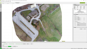
Stitched image comprised of 64 individual high resolution photographs
DRONES & PHOTOGRAMMETRY
What we find fascinating at Droneboy is the intersection of existing practices and the application of drones. Photogrammetry is one of those well established practices that is undergoing a monumental shift in its application as a result of drones. The science of photogrammetry is not new and is a widely used tool to perform measurements such as distance, grade, volume, etc… using photographs of large scale projects (eg construction sites, buildings, stockpiles, etc…). Drones are great at taking pictures of large scale objects. Put the two together and you open up a whole new set of uses and applications.
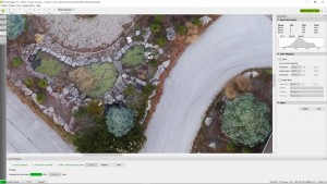
Zoom in on local detail
By analyzing multiple photos of an object or scene, our very sophisticated software running complex algorithms is used to identify thousands of common points across images, link them together and actually recreate a 3D representation of the original 2D images! The accuracy is such that you can actually use the resulting 3D image that is created to perform very accurate distance, area, volume and grade measurements as well as show elevation changes.
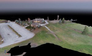
3d representation viewable from any angle
You have likely seen results of this process for instance in Google’s 2 D and 3D Maps. So what’s changed? Well, by using drones as a tool to capture the original images, we now have the ability to create that map or 3D representation of your project as it looks today, not as it looked 2 years ago, when google came by! Even better, if you have a large ongoing project, we can collect images yearly, monthly, weekly or daily to show the progress of the project thereby eliminating the need for remote site visits by multiple people.
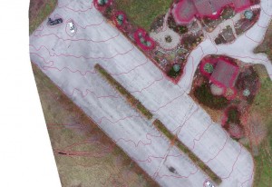
Contour lines showing 30cm elevation change
While new applications of this capability are appearing daily here are just a few examples:
Drones are a very time and cost effective tool for the collection of aerial images of large objects and areas <1000 acres. At Droneboy we believe that by taking this new image capture capability, and applying the new developments in the software, that there is a new area of opportunity for our clients to reduce costs, improve the timeliness of information, and manage projects to further their business.
If you have a need for this type of technology or see a new way in which it could be applied for your business, we can work with you to discuss these opportunities and bring these capabilities to your organization.